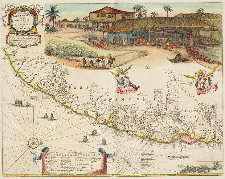
Map of Paranambuca Pars Borealis (northern Pernambuco) and Itâmaracá (Itamaracá) in volume 11, the New World, of Joan Blaeu’s Atlas Maior, engraving, 1662. Wichita State University Special Collections.
This map illustrates the northern region of Pernambuco, which was under Dutch control from 1630 to 1645. Embedded within the map are narrative scene depicitn ga sugar mill with laborings slaves in the upper right and a maritime battle scene dated January 12, 1640 at bottom left. The date references the first day of the battle between the Dutch and Portuguese. This map was also previously published in Caspar Barlaeus’s Rerum per octennium in Brasilia of 1647.
Key bottom right: a. Ilha dos cedros, ou d’ant:o Vaaz. / b. Citade Maurtia, v. Maurits Stadt. c. F. Frederick Henrick, V: Vyfhoeck. / d. F. Ernestus, daer by Vryburg ligt. / e. F. Waerdenberg, v. dryhoeck. / f. Stede Reciff. / g. Watercasteel, v. Castello do mar. / h. Castello de S. Iorge, v. Landtcasteel. k. Fort de Bruyn. / l. F. Ioffrou de Bruyn. / m. F. Prins Willem aen R. dos Affogados. / n. Rio dos Afogados. / o. Teiibipio, eene rivier. / p. Capiibari, een rivier. / q. Iabebiri, een rivier
Key on left: 1. Guaibitingamiri. / 2. Fonte de S. Thom??. / 3. R. Tapado. / 4. R. de Graspar Gon??alo
I. XII. Ianuarij an. MDCXL. conflixit Primo cum Hollandorum cla??e, Hispanica, hac altitudine ex adverso I. Tamarica
Literature
Sutton, Elizabeth. “Possessing Brazil in Print, 1630-54.” Journal of Historians of Netherlandish Art 5, no. 1 (2013): DOI: 10.5092/jhna.2013.5.1.3.
Image
For a high-resolution image and more information, see: http://www.atlasofmutualheritage.nl/en/Map-Pernambuco-Tamarica.7745
Image source: https://cdm15942.contentdm.oclc.org/digital/collection/p15942coll16/id/70
